Showing posts with label Cumberland Trail. Show all posts

Sunday, August 30, 2015

Cumberland Trail Graysville Mountain Segment

     With my wife's summer classes over and me having a weekend off from work, we decided it was time to go hiking again. Between her school and my work schedule, we have not had much time to get away from the house other than for the necessary trips.  I began looking for the place to go and a new waterfall on Tuesday and by Wednesday had decided on the Cumberland Trail.  I will confess that I am developing a love hate relationship with this trail.  I love it because it is a long distance trail within Tennessee, and like the Benton MacKaye Trail, is only about an hour, probably less, from my house.  I also love the views you get from being on top of the plateau and the many waterfalls that the trail goes by.  See it is these waterfalls that help me to convince the wife that we should hike on this trail. If the Benton MacKaye Trail had as many waterfalls close by we would probably have hiked more of it.  The hate part of the relationship is that it is incomplete. I know it takes years to finalize a trail's path and even then it is changed over time, but the Cumberland Trail Conference appears to only be working on connecting the northern end of the trail. Now before I go too far, I don't want people to think I do not know about or have forgotten the 30 miles of trail in the Three Gorges Section, because I haven't. It is just that other than that and the Mullen's Cove Loop there are not any substantial parts of the trail connected below Crossville.  I really appreciate all of the hard work that the trail crews and the trail maintainers put into keeping the trail open for everyone to enjoy.  I guess I am part of the Gimme Generation and wish that the trail was open NOW, but I know that once it is completed it will be a trail that has been well worth the wait.
This is a screen capture of my track using the AllTrails app
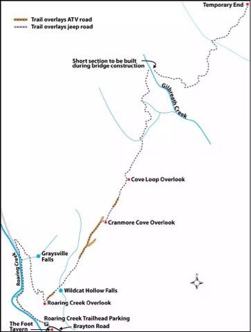
This is the trail map given by the Cumberland Trail Conference on their website
     We were dog sitting for the in-laws this weekend and it took us a little longer to get their dog ready to go on the hike.  In thinking that I wanted to ditch my roughly 15 year old Eureka! day pack, I decided to use my Jansport Carson 90 liter external frame pack.  That was an interesting decision.

The Trail head
I was definitely over packed for what I needed for the day!  I was carrying 2 liters of water in my hydration bladder, an ENO double nest and straps, an ENO Pro Fly, first aid kit, another liter of water and a smalbowl for the dogs, some tp, snacks, and about 85 liters of air.  But hey if we never experiment, we never know what will work and what won't.  After looking at the CT's website and watching a YouTube video I knew that the trail started out fairly level so I wasn't too worried about getting the pack dialed in completely before we took off.  When we got to the trail head, I was happy to see that we were the only car there.  Being a nice weekend I was afraid that the trail would be crowded, but it was not.  My wife says that it was because we went hiking instead of shopping on tax free weekend.  To each their own I guess.  One thing to note, cars need to be careful pulling in to the parking area as the gravel is washed away from the pavement and the right hand side has a larger drop off than the left, as of our trip.  I made sure to ease the Cobalt down off the road.
     The trail began fairly level on an old roadbed.  The dogs loved running back and forth from one side of the road to the other.  My in-law's dog stayed in the bushes for most of this part of the hike and we had to pull some ticks off of him because of it.  The trail parallels a stream with some wet weather 
The Right Hand Turn about .8 miles from Trail Head
streams crossing the trail after heavy rains.  It was a nice hike.  The gravels in the road are fairly well compacted so you do not have to worry about turning an ankle or anything of that nature.  The road forms a Y and we followed the solid white blazes to the right and began a slightly higher climb.  It was after this turn that I began to get antsy about making sure we did not miss the cut off to the right before we began our climb up the plateau.  For some reason this really concerned me this day.  But after about a mile from the car, we saw it.  The two white markers were clearly visible, as was the trail.  My wife looked at it and said, "So I guess we go up now?"  I just smiled back and the dogs took off.  Some parts of the CT that we have been on have very steep ascents/descents and I was slightly concerned how this one might be, but it was the smoothest climb we have had to date.  I also enjoyed the air being a little cooler as we climbed.  For the most part, the trail is like the picture to the left, but after about a mile, we came to a grassy grown up area on the trail.  The grass was about knee high and quite unexpected.  My wife picked up Mia and carried her through this patch to help prevent the possibility of ticks.
     After about a mile and a quarter, I could hear the waterfall, which was the second reason I chose this trail to hike.  We were coming around a bend in the trail and could just make out the stream from the bottom of the waterfall when my brain screamed STOP!  So I stopped and looked down.  There laid out in on the side of the trail with the in-law's dog standing beside it was a five foot long black snake sunning itself.  I called the in-law's dog back to me and began to check the snake out.  I looked to see if it was digesting anything, but saw no large lumps along its length.  Then I looked to see if it was shedding its skin, which it wasn't.  I said, "Well snake will you let us pass or do we need to take the long way around?"  I took a step towards it, but like I was walking past it, and it took off like a shot down the side of the trail and back to the creek.  Both dogs finally saw the snake at that point.  I put my heart back in my chest and we walked over to the waterfall.  It was running fairly well and my wife got several good shots of it with her camera.  I was having to hold the dogs and had forgotten my camera at home.  The previous shots were all taken with my iPhone and I just have never been able to master taking a good waterfall picture with a phone.  So we hit the waterfall at about a mile and a quarter, like I said earlier.  We rested for about five minutes and went on.
     I knew that at two miles, according to the mileage listed on the CT's website, that there would be an overlook.  I mentally picked the overlook as my turn around spot.  The trail runs for a total of about 5 miles, but we were not physically ready for a 10 mile day and neither were the dogs.  So we hiked on.  The trail got a little rougher here.  There were rocks that we had to go between and climb over; nothing too hard just large enough rocks to make the trail interesting and the trail was well marked in this area.  I knew that we had made a decent climb up from the car so far and was beginning to feel it.  The trail began to switchback more that it had previously.  My special day pack was letting me know it was there.  I checked my phone and we had hit the two mile mark.  Thinking that my phone was off, I asked my wife what her Fitbit told her she had walked and it said two miles as well.  Then both dogs laid down in the trail.  They just decided they were done.  I pulled out the water and bowl and gave them some more water.  We all sat down then and took about a ten minute break.  Mia the Hiking Chihuahua was ready to get back on the trail but my Scout, the in-law's dog, was ready to go to the car.  I looked at the map and figured that we had at least a quarter of a mile more before we made it to the overlook.   I knew then that either the mileage on the website was a tad bit off or our two mileage trackers were off, possibly even both.  So, without making it to the overlook, we decided to go back to the car.  The trip back to the car was just as enjoyable as the trip up the side of the plateau, just without any snake sightings.  On the whole, I would love to do this hike again, maybe catch it after a couple of days of good rain as there is another waterfall a little ways after the first overlook.  Maybe this section will be linked with another soon and some overnight camping would be in order, you know so that I could possibly have a real reason to be carrying that 90 liter pack.

Directions:  From Soddy Daisy, continue north on 27, turning left onto TN 303 for 0.4 mile, then right onto Dayton Avenue (still TN 303).Take the first left onto Pikeville Avenue for 1.6 miles as the road becomes Pikeville Blvd./Brayton Mountain Road. Just after a sharp curve left, the dirt and gravel parking area for the trailhead is on the right. The Foot, a local bar, is a cinder-block building on the left. (Borrowed from the CT website).  I just put 1721 Brayton Mountain Rd, Graysville, TN into my GPS and it got me there.  I did watch the linked video a couple of times just so I knew what to look for.

Sunday, August 3, 2014

Cumberland Trail Stinging Fork Falls 10/26/2013

Reaching back into the archives for this trip.  Ever since I heard about the Cumberland Trail, I have been fascinated by it.  When it is finished, it will be a long distance trail that runs from Chattanooga, TN to Cumberland Gap National Historic Park on the Tennessee Kentucky line.  In 1998, the state has come in and decided to help with the trail, naming it the Justin P. Wilson Cumberland Trail State Park.  The trail will be a little over 300 miles long when completed.  There are currently 190 miles of trail open.  In my mind, this trail is like the Benton MacKaye Trail a long trail right in my back yard!
      Stinging Fork Falls like Virgin Falls and the Laurel-Snow Pocket Wilderness used to be owned by the Bowater Paper Company.  Bowater set the lands aside to not be logged noticing their beauty and then they donated the lands to the state.  The Stinging Fork Falls makes up the Falls Segment of the Cumberland Trail.  So far the trail to the waterfall and the overlook are the only constructed parts of the Cumberland Trail constructed in the Falls Segment.  The Cumberland Trail Conference currently does not know how it is going to route the trail through this segment.
The trail from the parking lot
     I always like to find an excuse to hike on the Cumberland Trail.  My wife like to hike when the trail goes by a waterfall.  She says that it give us something to look forward to.  So when I can, I try to find a trail that takes us to a waterfall.  After searching and running the numbers, translates to driving time vs. hiking miles, I ran Stinging Fork by Jackie.  She was up for it. We drove to the trailhead and saw another couple getting out of their car for a hike.  The parking lot is right on the side of the road.  It would hold around six cars.  The trail starts from the side of the parking lot and goes downhill from the start.  It is not a bad slope, but it is downhill.  As the picture shows, the trail starts off grassy, but once past the curve it turns to a dirt trail.
     After half a mile, the trail splits.  The trail that goes to the right, leads to the waterfall and the trail that goes to the left goes to the overlook.  We chose to go left since the other couple went right.  The trail is at most a quarter mile long.  It was fall when we went so the view was fairly good.  The only problem was, there wasn't much to see.  It wasn't a bad view and we were able to see up and down the gorge.
A panorama of the gorge
     We after we finished our pictures we went back to the split and went in the direction of the waterfall.  It was about a mile hike to the falls.  The trail comes to some stairs and then continues down into the gorge.  The trail then goes through several switchbacks while still going down towards the creek and the falls.  The trail becomes very rocky when it reaches the top of the falls.  There is another set of stairs leading down again that were beginning to fall apart when we were there.  As the trail goes down the stairs, it leads you away from the waterfall.  Once the trail reaches the bottom of the gorge it drops into an old roadbed and turns to the left to go back to the fall.
End of Trail at the Falls
     We had not had a lot of rain when we went to the waterfall and it was a little disappointing.  We had hiked to see the waterfall but it was just a trickle.  I could imagine how the waterfall would look running full, but after putting in the work, it was a little disappointing to have to imagine how it would look.
     We hiked back to the car, going a little slower.  It was tougher going back up the gorge to the car.  Once we reached the trail split the trail eased out.  We had hiked some parts of the Cumberland Trail before and I have decided to dub it the trail of switchbacks.  With how the trail is laid out and the terrain that it covers, the trail makers have little choice but to use switchbacks.
Little Hiker Guy I like these
Stairs needing repairs
I would this trail to people.  I have high hopes for how the Cumberland Trail will run when it is finished.  The only thing for this particular trail would be to go after some rain, but that is standard advice for just about any waterfall.  For the Cumberland Trail Conference's page on the hike, visit this page: http://cumberlandtrail.org/website/maps-and-guides/trail-segments/stinging-fork/