Sunday, August 30, 2015

Cumberland Trail Graysville Mountain Segment

     With my wife's summer classes over and me having a weekend off from work, we decided it was time to go hiking again. Between her school and my work schedule, we have not had much time to get away from the house other than for the necessary trips.  I began looking for the place to go and a new waterfall on Tuesday and by Wednesday had decided on the Cumberland Trail.  I will confess that I am developing a love hate relationship with this trail.  I love it because it is a long distance trail within Tennessee, and like the Benton MacKaye Trail, is only about an hour, probably less, from my house.  I also love the views you get from being on top of the plateau and the many waterfalls that the trail goes by.  See it is these waterfalls that help me to convince the wife that we should hike on this trail. If the Benton MacKaye Trail had as many waterfalls close by we would probably have hiked more of it.  The hate part of the relationship is that it is incomplete. I know it takes years to finalize a trail's path and even then it is changed over time, but the Cumberland Trail Conference appears to only be working on connecting the northern end of the trail. Now before I go too far, I don't want people to think I do not know about or have forgotten the 30 miles of trail in the Three Gorges Section, because I haven't. It is just that other than that and the Mullen's Cove Loop there are not any substantial parts of the trail connected below Crossville.  I really appreciate all of the hard work that the trail crews and the trail maintainers put into keeping the trail open for everyone to enjoy.  I guess I am part of the Gimme Generation and wish that the trail was open NOW, but I know that once it is completed it will be a trail that has been well worth the wait.
This is a screen capture of my track using the AllTrails app
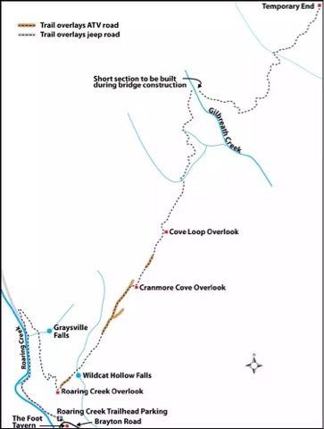
This is the trail map given by the Cumberland Trail Conference on their website
     We were dog sitting for the in-laws this weekend and it took us a little longer to get their dog ready to go on the hike.  In thinking that I wanted to ditch my roughly 15 year old Eureka! day pack, I decided to use my Jansport Carson 90 liter external frame pack.  That was an interesting decision.

The Trail head
I was definitely over packed for what I needed for the day!  I was carrying 2 liters of water in my hydration bladder, an ENO double nest and straps, an ENO Pro Fly, first aid kit, another liter of water and a smalbowl for the dogs, some tp, snacks, and about 85 liters of air.  But hey if we never experiment, we never know what will work and what won't.  After looking at the CT's website and watching a YouTube video I knew that the trail started out fairly level so I wasn't too worried about getting the pack dialed in completely before we took off.  When we got to the trail head, I was happy to see that we were the only car there.  Being a nice weekend I was afraid that the trail would be crowded, but it was not.  My wife says that it was because we went hiking instead of shopping on tax free weekend.  To each their own I guess.  One thing to note, cars need to be careful pulling in to the parking area as the gravel is washed away from the pavement and the right hand side has a larger drop off than the left, as of our trip.  I made sure to ease the Cobalt down off the road.
     The trail began fairly level on an old roadbed.  The dogs loved running back and forth from one side of the road to the other.  My in-law's dog stayed in the bushes for most of this part of the hike and we had to pull some ticks off of him because of it.  The trail parallels a stream with some wet weather 
The Right Hand Turn about .8 miles from Trail Head
streams crossing the trail after heavy rains.  It was a nice hike.  The gravels in the road are fairly well compacted so you do not have to worry about turning an ankle or anything of that nature.  The road forms a Y and we followed the solid white blazes to the right and began a slightly higher climb.  It was after this turn that I began to get antsy about making sure we did not miss the cut off to the right before we began our climb up the plateau.  For some reason this really concerned me this day.  But after about a mile from the car, we saw it.  The two white markers were clearly visible, as was the trail.  My wife looked at it and said, "So I guess we go up now?"  I just smiled back and the dogs took off.  Some parts of the CT that we have been on have very steep ascents/descents and I was slightly concerned how this one might be, but it was the smoothest climb we have had to date.  I also enjoyed the air being a little cooler as we climbed.  For the most part, the trail is like the picture to the left, but after about a mile, we came to a grassy grown up area on the trail.  The grass was about knee high and quite unexpected.  My wife picked up Mia and carried her through this patch to help prevent the possibility of ticks.
     After about a mile and a quarter, I could hear the waterfall, which was the second reason I chose this trail to hike.  We were coming around a bend in the trail and could just make out the stream from the bottom of the waterfall when my brain screamed STOP!  So I stopped and looked down.  There laid out in on the side of the trail with the in-law's dog standing beside it was a five foot long black snake sunning itself.  I called the in-law's dog back to me and began to check the snake out.  I looked to see if it was digesting anything, but saw no large lumps along its length.  Then I looked to see if it was shedding its skin, which it wasn't.  I said, "Well snake will you let us pass or do we need to take the long way around?"  I took a step towards it, but like I was walking past it, and it took off like a shot down the side of the trail and back to the creek.  Both dogs finally saw the snake at that point.  I put my heart back in my chest and we walked over to the waterfall.  It was running fairly well and my wife got several good shots of it with her camera.  I was having to hold the dogs and had forgotten my camera at home.  The previous shots were all taken with my iPhone and I just have never been able to master taking a good waterfall picture with a phone.  So we hit the waterfall at about a mile and a quarter, like I said earlier.  We rested for about five minutes and went on.
     I knew that at two miles, according to the mileage listed on the CT's website, that there would be an overlook.  I mentally picked the overlook as my turn around spot.  The trail runs for a total of about 5 miles, but we were not physically ready for a 10 mile day and neither were the dogs.  So we hiked on.  The trail got a little rougher here.  There were rocks that we had to go between and climb over; nothing too hard just large enough rocks to make the trail interesting and the trail was well marked in this area.  I knew that we had made a decent climb up from the car so far and was beginning to feel it.  The trail began to switchback more that it had previously.  My special day pack was letting me know it was there.  I checked my phone and we had hit the two mile mark.  Thinking that my phone was off, I asked my wife what her Fitbit told her she had walked and it said two miles as well.  Then both dogs laid down in the trail.  They just decided they were done.  I pulled out the water and bowl and gave them some more water.  We all sat down then and took about a ten minute break.  Mia the Hiking Chihuahua was ready to get back on the trail but my Scout, the in-law's dog, was ready to go to the car.  I looked at the map and figured that we had at least a quarter of a mile more before we made it to the overlook.   I knew then that either the mileage on the website was a tad bit off or our two mileage trackers were off, possibly even both.  So, without making it to the overlook, we decided to go back to the car.  The trip back to the car was just as enjoyable as the trip up the side of the plateau, just without any snake sightings.  On the whole, I would love to do this hike again, maybe catch it after a couple of days of good rain as there is another waterfall a little ways after the first overlook.  Maybe this section will be linked with another soon and some overnight camping would be in order, you know so that I could possibly have a real reason to be carrying that 90 liter pack.

Directions:  From Soddy Daisy, continue north on 27, turning left onto TN 303 for 0.4 mile, then right onto Dayton Avenue (still TN 303).Take the first left onto Pikeville Avenue for 1.6 miles as the road becomes Pikeville Blvd./Brayton Mountain Road. Just after a sharp curve left, the dirt and gravel parking area for the trailhead is on the right. The Foot, a local bar, is a cinder-block building on the left. (Borrowed from the CT website).  I just put 1721 Brayton Mountain Rd, Graysville, TN into my GPS and it got me there.  I did watch the linked video a couple of times just so I knew what to look for.

Monday, February 2, 2015

Book(s) Review!

     Hello everyone!  With the rain coming down and a ton of MBA homework to be done, there was no hiking trip this week.  An unfortunate occurrence, but hey life happens every now and then and we have to roll with the punches.  So while my wife works on her homework, I thought I would do some book reviews that I have been planning for a while.  The reviews will focus on the books I most use for planning our hiking adventures
     I will start off with the book that started it all, Cherokee National Forest Hiking Guide edited by Jim Casada.  I consider this to the the trail bible of MOST of the trails in the Cherokee National Forest.  I have only used the half of the book dealing with the southern half of the forest so I cannot comment on how it handles the northern part.  I find that this book does a good job describing the trails and giving mileage that is fairly close to what we step off on a hike.  One of the things I like about this book is that the authors tell you what to expect on the trail without giving anything away.  Some book are written in a way that after you read the description, there's no point in going on the hike due to every little detail being given out.  That is not the case with this book.  The down side to this book is the maps.  Just a general over view with dotted lines and numbers showing the trail.  I would not use the maps in the book to direct me on trail.  Plus at a total 566 pages long, it is a little heavy to carry on the trail; even though I have done it.  The directions to the trail head are written in a strait forward and easy to follow manner.  Just make sure to watch the odometer if they list miles to a turn!  If there is any interest at all in hiking the Cherokee National Forest, pick this book up.  I linked it to Amazon, but bought mine at Books-A-Million and have seen several copies at the National Forest Office in my town.  I give this book 4 1/2 stars.
     Jackie bought the next book, Waterfalls of Tennessee by Gregory Plumb.  It is an ok trail book.  She loves to go to waterfalls on hikes.  She loves them so much, that in the 7 years we have known each other we have been to 57 waterfalls and counting (that total does not count the repeat hikes we have taken to some of the falls).  The book is good for a general overview of where the falls are located and how the trail is getting there.  I do find Mr. Plumb's ratings of the waterfalls to be fairly accurate.  If he says there isn't much to see, then unless the creek/river is in flood stage, there isn't much to see.  The trail descriptions are just blurbs and do not count on using the maps while on the trail.  The driving directions are okay at best.  There have been a couple of times while going to the some of the falls in the book that I had to turn around or stop and ask locals for directions due to how they are written in the book.  It would have been helpful to have a GPS location of the trail head listed, but they are not.  Just a throwback to the days of paper maps, no GPS, and cheap gas I guess.  Please don't think I hate this book, it is nice for what it is and that is a book all about waterfalls and a general way of how to get there.  I used this book to find Lula Lake Waterfall on Lookout Mountain and Falling Water Falls in Walden, TN.  If you want more details of the hike, you need to buy another book dealing with the area where you will be hiking.  I give this book 3 stars.
     After stumbling upon Savage Gulf's Stone Door, Jackie and I stopped on the way home and bought, 40 Hikes in Tennessee's South Cumberland  by Russ Manning.  This is a slim book coming in at a total 141 pages with some blank pages in the back for notes.  The book deals with a selective list of hikes south of I-40 on the Cumberland Plateau.  This book walks the fine line of a detailed trail description and giving the hike away.  There were a couple of times that I felt a little less info could have been given an the description would not have been the worse for ware.  Mr. Manning gives mileage, that again is close if not right on to what I get, and a difficulty rating of the trail.  Pay attention to the rating, I have found that Mr. Manning is a fair trail rater.  There are maps included before each section being discussed.  In a pinch, and I have done this as well, the maps can be used on the trail.  The maps are not super detailed, but they are workable.  With the Cumberland Tail Conference working hard to finish their trail and the book being published in 2000, the information in the book is now a little dated.  It is still a very serviceable book though.  Some trails will not change, like those in the State Parks or the trails around Sewanee, but just check the Cumberland Trail Conference page before hitting any of their trails from the North Chickamauga Pocket Wilderness northward.  I really enjoy this book and use it to plan my trips in Savage Gulf.  I give this book 4 1/2 stars.
     The next two book really go together, Hiking Tails of the Smokies and Waterfalls of the Smokies both published by Great Smoky Mountain Association.  These are top notch trail books.  A lot of people call Hiking Trails of the Smokies the Trail Bible of GSMNP.  Each and every trail of the park is listed in detail.  Each trail comes with an elevation profile, so you know what you are getting into, and a trail rating.  Since Jackie likes to hike to waterfalls, I use both books to plan out the hike.  I like how one plays off of the other.  For a quick overview of what we will be getting into, I look over the waterfalls, but for a detailed turn by turn mile by mile, I look at Hiking Trails.  Hiking Trails also comes with a large park map, the kind that you can pick up at the Visitor's Center or download from the website; not great for being lost in the woods, but serviceable for being on trail and figuring out how to get there.  The good thing about both of these books is that they are pocket sized.  Now Hiking Trails may be a little bulky but it still would be a good thing to have in the top of your pack.  If you were only to get one book on Smokies Hiking, get Hiking Trails for it's depth of information.  I give both books a 5 star rating.
     The newest book in my collection is 50 Hikes on Tennessee's Cumberland Plateau by Johnny Molloy.  I have yet to use this book on trail, but reading his descriptions of some trails that I have previously been on, he is spot on.  He has the usual length, difficulty, and elevation loss/gain and serviceable trail maps.  I wouldn't really want to carry the 240 page book through the woods, but it wouldn't too bad.  I am already using the book to plan a couple of trips to the Scott's Gulf area by Virgin Falls.  Some of his descriptions are better than the ones in 40 Hikes in the South Cumberland, and both books cover the same ground but I like having both to compare.  Mr. Molloy's book covers more of the Cumberland Trail than 40 Hikes, and it also runs from the Kentucky line to the Alabama line.  His book is the first I have found to mention hikes in Frozen Head State Park, which is one of the main reasons I bought it.  So being untested, I will give the book 4 1/2 stars.
     I hope that this review will help you if you are in search of trail guides for East Tennessee.  There are many trails out there and not every trail is covered by a book.  Sometimes part of the adventure is just finding the trail.  I know I don't think I will ever forget that herd of blood thirsty Chihuahuas that came after me when I stopped and asked a guy how to find Turtletown Falls, but that is a story best left untold.

Sunday, January 18, 2015

Benton Falls, The First Hike of 2015!

Benton Falls Running Full
     For the past four years, a hike to Benton Falls in the Cherokee National Forest has been our first hike of the year.  I have been hiking there so much, that I can practically hike the trail in my sleep.  To prove that to myself, I did hike about a mile of the trail while reading a book one time.  But I digress back to the trip.  Yesterday, 1/17/15, we went for the first hike.  I purchased one of the annual passes for the Cherokee Forest and it was our first use of it.
Looking down from the top of the falls
     There were several cars in the parking lot so I expected the trail to be busy, but we hardly saw anyone.  The trail heads from the parking lot and goes across the dam holding back McKamy Lake.  Then it turns left and beings to descend the mountain heading towards the falls.  Overall, the trail is 1.5 miles long.  Hikes and Mountain Bikers share the trail,  I was super surprised that there were no mountain bikers.  We did not see anyone till we were almost to the waterfall.  The trail is mostly packed sand, but there are rocks that need to be watched for.  Going to the waterfall, it is downhill all the way so it takes no time to reach the stairs that lead to the base of the falls.  From the research that I have done, you loose about 300 feet from the parking lot to the base of the falls and you make it all back up going to the car.
     The trail starts off in a hardwood forest, then passes through a clear cut for power lines and then goes into a mixed forest with some pine trees.  The Pine Beetle has made its presence felt here, but I believe the Forest Service has it under control or the pest has moved on.  Once the trail comes close to Rock Creek, which is the creek that makes Benton, Rattlesnake, and Scenic Falls, Magnolia trees begin to become prominent.  From the main trail down to the top of the falls, there are steps, but going down to the bottom, there are rock steps that have been there for as long as I can remember.
     I do not want to give this trail short shift, but it is like an old friend; someone that you have known forever and have gotten used to the little details and nuances that make others stand out and appear spectacular.  Jackie and I use this trail now to take us to other trails in the area.  The Benton Falls Trail links up with the McKamy Lake Trail, Elderberry Trial, the Slick Rock Naked Widow Loop, Redleaf Trail, and the Clemmer Trail.  This one little 1.5 mile trail allows you to hook together trails that can run in length from 3 miles to just about as long as you want to walk.  We have used this trail to go to the Clemmer Trail and then the Rim Rock trail across to the Clear Creek Trail and back up to the Beach Trail for a hike that ran 7.5 miles.  Needless to say I forgot how to add and told Jackie it would be about 4 miles total and she went for a 2 mile run that morning.  She wasn't real happy with me, but I got the Trangia 25 Stove system due to that hike!
     I always like to try and end our Benton Falls hike with a trip around McKamy Lake.  I look for fish or anything else I might see.  The last time we hiked the lake, from the Gazebo Trail, we saw 3 Water Moccasins.  This trip there was ice still on the lake from our colder temps earlier in the week.  As we were making the turn past the Campground Loop A area, I spotted this turtle sunning itself.  I pointed it out to Jackie, snapped a quick pick and moved on.  It was a good way to end the hike.
Turtle trying to get warm in the sun 

Savage Day Loop 10/25/2014

     About five years ago, Jackie and I made our first trip to Savage Gulf State Natural Area.  We fell in love with the place.  We love it so much, that I proposed to Jackie at the Stone Door.  Last year was an interesting year for us, with so much going on.  I regret to say that we only made one trip, yes just ONE trip to Savage Gulf, but it was an interesting trip none the less!
     We decided to do the Savage Day Loop Trail.  We unfortunately did not have a ton of time to do a backpacking trip and my knee was still giving me fits from the Rainbow Falls hike in September.  It was a good thing that we did not plan on doing an overnighter anyway because all of the back country campgrounds were full.  We arrived a little after lunch to find the parking lots completely full.  Outside of a handicapped space, I grabbed the last spot in the open lot.  There was another parking lot, but it was closed due to being the off season.  With great anticipation, I got my pack out of the trunk and helped Jackie into hers and we were off!
     The trail beings just to the right of the Ranger Station.  For those interested, there are a couple of restrooms at the Ranger Station.  I did not use them so I cannot comment on size and cleanliness.  There was a group of about 7 people at the trail register when we arrived getting ready to head out.  They all had 60-80 liter packs and grunted under the weight of lifting them up.  They asked me to take a group picture for them, which I gladly did and asked how long they were going to be out.  A guy sheepishly said, "One night."  I laughed and said, "At least you all will eat pretty well."  We signed the register and the group told us to head out before them, but they were out pacing us, so we let them by.
Trail Register at the Savage Gulf Ranger Station
     The trail was fairly level.  It just meandered its way through the woods and was well graded.  We met several people heading back to their cars.  About .4-.5 tenths of a mile from the trailhead, we came into and area with substantial blowdown damage.  I was a little depressed to see all the trees down along and around the trail.  The trail goes through the damaged area and twists and turns its way past cut trees.  The damaged area of the trail is maybe 2 tenths of a mile in length. 
Part of the trail with downed trees.
      After the damaged area, there was a suspension bridge over a creek.  I always enjoy suspension bridges, and this one had the customary 2 people only sign.  The trail then came to a split.  We could go straight and then turn right to go to Save Falls and Rattlesnake Point overlook or we could go right and see the sights in reverse.  We chose to go right and hike the loop counterclockwise.  Going against the flow is something that we do.  By going right, we were on the path to connect with the North Rim Trail.  As an aside, I have heard that the North Rim Trail has some of the best overlooks in the Park, but I do not know for sure since I have not hiked any of it.  We set out on this route heading towards Rattlesnake Point 1.2 miles away.  This part of the trail follows an old narrow gauge logging railroad that went through the area in the 1920's.  That translates to easy grades and no real sharp turns.  The trail goes through forest, weaving its way through stands of trees and along the sides of hill.  When the trail reaches about 3 tenths of a mile from the point, it begins to drop down towards the edge of the Gulf.  It is a gradual decent, but I would not want to climb it on the way out after hiking about 2.5 miles and going back to the car.
Then there it is, Rattlesnake Point.  It is not a developed lookout like Laurel Point or the Stone Door, but the view is nice.  There are some rocks that you can step out on to get a better view, but do not expect wide open views.  I was please that we started with the overlook.  We had a few snacks and read the plaque.  The plaque commemorates the husband and wife who bought the land to help found the park in the 1930's.  There is not a lot of room at the overlook; so if you have little ones, keep a close eye on them.  Also, do not plan on being able to cook lunch at the point, as there is not really enough room, especially if there are other people there.  The trail comes out of the trees just to the left of the picture and runs at the base of the rock bearing the plaque in the picture.  Coming from Savage Falls, Rattlesnake Point could take you by surprise.    
     We continued our counterclockwise route.  The trail follows along the edge of the gulf for a little ways before climbing up and down some of the drainage routes that go to the edge.  After half a mile, the trail goes to the Savage Falls Overlook.  It is a fairly steep tenth of a mile down to the overview.  There is a small platform built to look at the
View of Savage Falls from the Overlook
falls.  Jackie and I were both barely able to stand on the platform and I had to hold Mia.  Jackie took several pictures of the falls and used her longer zoom lenses to get super close up pictures.  The picture to the right is the best that my Pentax WG-1 camera could do.  We could hear the roar of the falls from where we were standing.  The Park had set up signs saying that the trail ended and to not go any further.  I saw where people had gone past the stand to get a closer look.  If you want to go to the base of the falls, it is only .5 miles on the South Rim Trail to reach the overlook and the stairs leading to the base of the falls.  I had brought my film camera but was unable to take any pictures of the falls due to a family coming down the trail and trying to fit their 5 people onto the stand with us on it and there was just not room.  I just put my camera away and began to climb back up the trail.  It is times like that, that reminds me why I like to hike, to get away from everyone and spend time in the outdoors. 
Trangia 25 cooking my lunch
     After climbing back up to the trail, we continued on to the intersection with the South Rim Trail, and then the sign where we turned right.  We were a mile away from Ranger Station at this point.  We met a lot of people coming down to see the falls.  Even with the camp grounds full and closes, we passed several groups going in with packs on their backs.  I hope that they had a way to reserve a spot ahead of time.  Going back to the car either seems to take forever or flys by.  Today it sped by.  We made it back to the car in what felt like rapid time.  I got out my Trangia 25 and cooked us some grilled cheese sandwiches on the grills in the park.  I have not cooked much on the Trangia, but it can hold its own cooking grilled cheese and fried bologna!  I generally take it to work and cook a quick sandwich or two for lunch.  
     Overall, the trip was very enjoyable.  I felt like the Savage Gulf Ranger Station was out of the way compared to the other entrances of the park, but after spending time there, I think that it is well worth the effort.  If you go there and arrive too late to hike to one of the camping areas further in the park, there is a campground about a tenth of a mile past the Ranger Station.  It is not as developed as the Stone Door Entrance, but not as spare as the Collins Gulf and Greeter Falls Entrances either.  If you are only interested in seeing waterfalls, and get up early enough in the day, it is possible to hit Savage Gulf and then drive 19 miles on Hwy 111 to Fall Creek Falls State Park as well.

Directions: The Savage Gulf entrance and ranger station is located halfway along Highway 399 between Cagle and Gruetli-Laager. (from the State Website.  Oh so super helpful I know.)

Sunday, October 19, 2014

Rainbow Falls Hike GSMNP

Elevation Profile shamelessly borrowed from
hikingthesmokys.com
     A month ago, Jackie and I went to Rainbow Falls in the Great Smoky Mountains National Park.  We were planning on hiking Chimney Tops, but Jackie was not into scrambling over the rocks.  We were hoping to catch Chimney Tops on a weekday when the pressure would be less, but the Park is doing work and the trail is only open on the weekends.  So going through my Smoky Hiking books, I chose Rainbow Falls.  This was an area of the park that we had not hiked before.  I was hoping for an early, early start so that we might possibly be able to go to Rainbow Falls and Groto Falls, which would have us hiking about 6-7 miles, but we did not get that early of a start.
The trail head just passed the signs
     We left our home about 12 and got to the trail head around 2 PM.  There are some restrooms at the trailhead.  They are the standard pit toilets that are found throughout National Parks and Forest Service areas.  If needed, the restrooms are some of the best ones I have seen.  The trail head is on the Roar Fork Nature Trail out of Gatlinburg.  This makes it one of the more popular trails within the park.  Something about being easy to drive to, translates to being popular.  One thing I must say though, be ready to hike up hill the whole way.  This is one trail that starts off on an uphill and only ends when you get to your destination.  The Rainbow Falls trail is one of the trails that allows you to hike to the top of Mount LeConte and the Mount LeConte Lodge.
     The trail starts off innocently enough.  Make sure to stay close to the signs though, many people have made short cuts to save a couple of steps.  Just after the left turn in the picture above, the trail begins to get into its normal swing.  There are rocks and roots that fill the trail and it is pretty much constant for the first mile.  There was a power couple who were crunching through the trail and stopping to take pictures every tenth of a mile or so.  I was amazed at how they were never getting sweaty.  I was about to sweat to death and they were still cool as a cucumber.  The trail switch backed several times in its climb.  The trail follows LeConte Creek for the first half mile or so and then it leaves it behind and the trail becomes a forest walk with switchbacks occurring fairly regularly.
The bridge at mile 1.7
     After 1.7 miles, the trail comes back to LeConte Creek again.  There is a log bridge built over the creek.  It was a nice place to catch our breath.  The picture takers ended their hike here.  I guess they felt a little sweat on their brow or had something else to do.  We were snacking when a girl caught up to us.  We had passed her earlier while she was going to the bathroom right on the side of the trail.  I know when you have to go, you have to go, but with your feet still in the trail and no brush cover?  I quickly figured out what was going on and turned around and talked to Jackie until she was done.  Getting back on track, the bridge is a one person affair and is a level spot on the trail.  With the creek making a waterfall behind/uphill from the bridge, it makes a good place for a quick photo op.
     After we passed the bridge, we kept going up the trail.  I let Jackie take the lead on the trail and we were talking about how the Park did not mark the trails with i's or paint or anything like that when we ran into two deer in the middle of the trail.  They looked at us and began to walk up the trail away from us.  Jackie kept trying to get close and take pictures, but with one of the deer being a faun, I was afraid of her getting too close and having mom come after her.  Another power hiking couple caught up to us, right after the deer turned a corner.  I told them about the deer being up ahead and they said thanks.  They guy started talking about how he hoped that they ran into a bear.  I rolled my eyes and told Jackie if they saw a bear, I was going to trip the guy as we ran down hill away from it.  They ran into the deer and took out their phones and started snapping pictures.  The deer began walking up the side of the mountain eating as they went.  It was a neat experience for us, something that had not happened before.  We were really excited about it.
Rainbow Falls!
     After seeing the deer and going up another switchback, I began to wonder if we would ever get to the waterfall.  I like to hike, but an uphill slog the entire way was not something that I was expecting.  I was really happy to run into the second bridge at mile 2.4.  The speed couple was there taking some selfies by the waterfall behind the bridge.  We hiked across the bridge, turned a curve and could hear the waterfall roughly two tenths of a mile away.  It had not rained much before we went on our hike.  I was hoping that there would be water going over the falls.  All of the information on the hike I had been able to find said that the hike should be good, even with little water.  The falls gets its name from a rainbow showing in the mist from the falls that appears in the afternoon.  We reach the falls around 4 PM and I was hoping for the rainbow effect, but we did not see it.  After a little scrambling, we were able to sit at the base of the falls.  We ate our snacks and drank some water and took a break.  It was a long climb up from the parking lot and we were both happy to take the rest break.  Unfortunately, we did not really plan for the time that it would take us to reach the falls, and the time it would take us to drive to the trail head.  So we were both really ready for lunch.
     We needed to rest further, but our hunger pushed us from the falls.  We started going back, and when we were about 2 miles from the car, I did something to my knee.  I do not know what I did, but it made the hike a long two miles back to the car.  The trail is a tough trail, with lots of rocks and tree roots.  If you are not ready for it, the trail can get you when you least suspect it as any trail can.  I did not want to say anything to Jackie, but by the time we reach the car, I was ready to start asking people in the lot for some hydros or morphine.  The doctors say that I just stretched the tendon that runs up the outside of my knee.  I know that I was glad that I was able to complete the 5.4 miles we hiked and made it to the car under my own power.
     We had ran into several people going up to the falls, and with it being after 4 PM, I did not expect to run into many other people.   Instead as we kept getting closer and closer to the car, we ran into more and more people going to the falls.  It took us a little over 2 hours to get to the falls and these people were just starting out.  Most did not have any water and the few I saw with drinks were taking Coke's and Dr. Peppers along.  I told Jackie that I wished them well but did not think that they would make it to the falls.
     Over all we enjoyed this hike.  True I messed up my knee some how but overall it was a good hike.  There is something about taking your special someone to a place they want to go to.  Plus being in the woods is always a good thing.  As long as the water is running, this hike would be a good one to do.  Always be ready for anything!  We had the two deer on the trail with us and as we were leaving, we saw a Momma Bear and two cubs with her.  I would recommend this trail to anyone with some time to spare in the Gatlinburg area.
     Directions:  Turn onto Historic Nature Trail Road at red light number 8 at Ripley's Believe It or Not.  Go out this road until it turns into the Roaring Fork Motor Nature Trail.  The first trail head is on the right.  If it and the parallel parking areas are full, there is another parking area on the right.  Parking at the second parking area will add about .5 miles to the hike.

Turtletown Falls Trip

     A little over 4 years to the day since we had last been to this trail, Jackie and I decided that we would redo this trail.  This trail has two waterfalls along it's 4 mile length.  The last time that we hiked this trail, we only went to one waterfall for some reason.  I would think that we were trying to get back to the paved roads before dark.  We did get lost and had to ask directions the last time we were there. I am happy to admit that I did not have to do that this time.
The Trail Head.  The trail begins in front of the Jeep
     Today, we got to the trailhead around 2.00 PM.  There was one car there already and a Jeep followed us in.  We clipped Mia's nails and headed up the trail.  The trail starts off following an old logging road going up a ridge.  After a steady climb, the road drops down the ridge and begins to follow the creek.  If one wanted to try and fish this stream, there are a couple of good looking holes, but I do not know if it holds any fish.  If you aren't into fishing, there are several good swimming holes along this stretch.  If there has been a lot of rain before hiking this trail, you might want to wear boots since there are little streams that cross the trail going to the creek.
 
This is the Choice.  Waterfalls go to the left if that is all you
want to see.  For a loop ending with the waterfalls, go
straight.
 After .7 miles the road begins to climb again.  Looking closely, off to the left there is a white blaze and a trail going down.  You have to make a choice here, straight or turn?  This time we went straight.  I wanted to end the hike with the waterfalls rather than begin with them.  We hiked up the ridge and then dropped down the back side.  The trail climbed back up another ridge and runs into another trail sign.  To go right would take you to another trailhead that requires an old Jeep or 4x4 to get to.  We turned left and walked along Shinbone Ridge.  The trail winds along this ridge for about 2 miles or so.  We ran into a woman and her dogs and talked waterfalls for a little bit before going on.  The trails comes to what looks like a Y after about .75 miles.  Make sure to stay right, on the road, if you want to get to the waterfalls.  If you want to camp and get away for a night, then go left up the ridge to a nice camp site.      After this Y, the trail goes down hill for the rest of the time.  The trail looks to dead end at Lower Turtletown Falls, but it does not.  Look closely for some of the white i's that mark the trail and it will take you to a lookout for the bottom falls.  Below is a video that I shot from the lookout for the falls.
 
The trail junction to look for.  Easily missed
     After looking at the waterfall, trace your way back along the trail.  Look closely for a tree marked with the white i and a trail going off on the right.  It is after the blow down damage that litters this part of the trail.  The trail goes from logging road to single track.  This trail is better marked than the logging road section, but paying attention following it would not be a problem.  After a mile, this trail comes to Upper Turtletown Falls.  There is a set of steps that the trail follows and to get to the base of the falls, there is a side trail to the right that leads to a viewing area.  The views of the upper falls are much better than the lower falls.  Below is a video that I shot of the Upper Falls.
     After climbing the steps from the Upper Falls, the trail switchbacks a couple of times and continues to climb.  After the switchbacks, the trail's climb is not too steep.  The trail is only .4 miles from the switchbacks to the main trail going back to the car.  
     Overall, this trail is not too difficult.  Make sure to go after a rain so that the falls will be running well.  There are some places along Shinbone Ridge where there might be a view during the winter, but the two waterfalls are the main attraction of this trail.  There are a couple of places to pitch a tent if you are looking for a quick night away.  I am glad that we revisited this trail.  It is always nice to have a secluded trail not too far from home when the urge comes for a quick get away.
  Directions:  take TN HWY 68 to the Farner, TN Post Office.  Turn onto the road running in front of the Post Office and cross the railroad tracks.  After crossing the tracks, take the first road on your left. It looks to be a driveway running right beside a house, but it is a road.  At the next Y, stay left.  There is another Y with Newman Road, stay left but know that you are close.  On the right in the woods ahead, there is the Forst Service road you are needing.  Take it for 1.5 miles to the trail head.  There is an improved creek crossing, with concrete helping to keep it from being rutted out.  This road is not bad.  My Chevy Cobalt did not have any problems going down this road.  If you use GPS, type in 1234 Farner, or Old Farner, Road.  You could all use the intersection feature for Farner Road and Forest Service Road 1166

Sunday, August 3, 2014

Cumberland Trail Stinging Fork Falls 10/26/2013

Reaching back into the archives for this trip.  Ever since I heard about the Cumberland Trail, I have been fascinated by it.  When it is finished, it will be a long distance trail that runs from Chattanooga, TN to Cumberland Gap National Historic Park on the Tennessee Kentucky line.  In 1998, the state has come in and decided to help with the trail, naming it the Justin P. Wilson Cumberland Trail State Park.  The trail will be a little over 300 miles long when completed.  There are currently 190 miles of trail open.  In my mind, this trail is like the Benton MacKaye Trail a long trail right in my back yard!
      Stinging Fork Falls like Virgin Falls and the Laurel-Snow Pocket Wilderness used to be owned by the Bowater Paper Company.  Bowater set the lands aside to not be logged noticing their beauty and then they donated the lands to the state.  The Stinging Fork Falls makes up the Falls Segment of the Cumberland Trail.  So far the trail to the waterfall and the overlook are the only constructed parts of the Cumberland Trail constructed in the Falls Segment.  The Cumberland Trail Conference currently does not know how it is going to route the trail through this segment.
The trail from the parking lot
     I always like to find an excuse to hike on the Cumberland Trail.  My wife like to hike when the trail goes by a waterfall.  She says that it give us something to look forward to.  So when I can, I try to find a trail that takes us to a waterfall.  After searching and running the numbers, translates to driving time vs. hiking miles, I ran Stinging Fork by Jackie.  She was up for it. We drove to the trailhead and saw another couple getting out of their car for a hike.  The parking lot is right on the side of the road.  It would hold around six cars.  The trail starts from the side of the parking lot and goes downhill from the start.  It is not a bad slope, but it is downhill.  As the picture shows, the trail starts off grassy, but once past the curve it turns to a dirt trail.
     After half a mile, the trail splits.  The trail that goes to the right, leads to the waterfall and the trail that goes to the left goes to the overlook.  We chose to go left since the other couple went right.  The trail is at most a quarter mile long.  It was fall when we went so the view was fairly good.  The only problem was, there wasn't much to see.  It wasn't a bad view and we were able to see up and down the gorge.
A panorama of the gorge
     We after we finished our pictures we went back to the split and went in the direction of the waterfall.  It was about a mile hike to the falls.  The trail comes to some stairs and then continues down into the gorge.  The trail then goes through several switchbacks while still going down towards the creek and the falls.  The trail becomes very rocky when it reaches the top of the falls.  There is another set of stairs leading down again that were beginning to fall apart when we were there.  As the trail goes down the stairs, it leads you away from the waterfall.  Once the trail reaches the bottom of the gorge it drops into an old roadbed and turns to the left to go back to the fall.
End of Trail at the Falls
     We had not had a lot of rain when we went to the waterfall and it was a little disappointing.  We had hiked to see the waterfall but it was just a trickle.  I could imagine how the waterfall would look running full, but after putting in the work, it was a little disappointing to have to imagine how it would look.
     We hiked back to the car, going a little slower.  It was tougher going back up the gorge to the car.  Once we reached the trail split the trail eased out.  We had hiked some parts of the Cumberland Trail before and I have decided to dub it the trail of switchbacks.  With how the trail is laid out and the terrain that it covers, the trail makers have little choice but to use switchbacks.
Little Hiker Guy I like these
Stairs needing repairs
I would this trail to people.  I have high hopes for how the Cumberland Trail will run when it is finished.  The only thing for this particular trail would be to go after some rain, but that is standard advice for just about any waterfall.  For the Cumberland Trail Conference's page on the hike, visit this page: http://cumberlandtrail.org/website/maps-and-guides/trail-segments/stinging-fork/